Welcome, Guest. Please login or register.
May 12, 2025, 07:29:40 AM

Login with username, password and session length

Recent Topics

[May 11, 2025, 09:36:38 AM]

[May 08, 2025, 09:53:46 AM]

[May 05, 2025, 09:12:01 AM]

[May 03, 2025, 06:39:16 PM]

by jed
[May 02, 2025, 09:57:11 AM]

[May 01, 2025, 05:53:19 PM]

[April 26, 2025, 04:27:54 PM]

[April 23, 2025, 11:10:07 AM]

by [WR]
[April 23, 2025, 09:15:13 AM]

[April 21, 2025, 10:44:08 AM]

[April 17, 2025, 04:48:17 PM]

[April 17, 2025, 08:45:02 AM]

by jed
[April 11, 2025, 01:03:22 PM]

[April 11, 2025, 06:19:31 AM]

[April 07, 2025, 07:03:34 AM]

Picture Of The Month


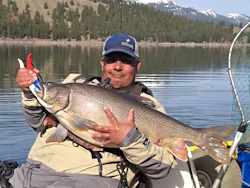
Guess who's back?
jed with a spring Big Mack

Topic: How to load Google Earth Data onto your Lowrance GPS FF/SD card  (Read 7598 times)

0 Members and 1 Guest are viewing this topic.

Wingshooter

  • Herring
  • **
  • Location: Sacramento, CA
  • Date Registered: Dec 2012
  • Posts: 41
I thought I would share this post I put up on NCKA awhile back.

Quote
How to export Google maps kmz files waypoints to Lowrance .usr file. SD card type FF needed.

1. http://www.gpsvisualizer.com/convert_input

choose GPX output format
browse for your google maps .kmz file
leave everything as default
convert

2. Your .gpx file was created.
click and download your .gpx file.
save to your desktop.

3. http://www.gpsvisualizer.com/gpsbabel/
input: scroll down and select GPX XML
output: scroll down and select Lowrance USR
browse for the .gpx file you created on your desktop
no - create zip file
yes - output all types of data
leave advanced option alone
hit - convert the file

4. Load the .usr file onto your micro sd or whatever card you have for your Lowrance.
Under the waypoints options on your fishfinder- load the file from card.
Select your .usr file and load.
All done go fish.

This is a very basic method to get your waypoints onto your FF. There are other methods to get your waypoints with different types of icons, routes, etc., but that will be another post in the future. I hope that this helps you guys out.

~ Mike  ;D

Lowrance Rockfish Classic Tourney Director
FreshKATs.com Series Coordinating Director

www.bransonbaits.com 
www.facebook.com/bransonbaits

US Hobie Fishing Team Member
Lowrance Pro-Staff
EGO Pro-Staff
Lew's Pro-Staff
P-Line VIP
Scotty Brand Ambassador


Romanian Redneck

  • snoodleboob smoochy bear
  • Sturgeon
  • *******
  • 2011 Hobie Outback & WS Tarpon 120
  • Location: Vancouver, WA
  • Date Registered: Feb 2012
  • Posts: 1979
Yes. Awesome. Thank you. I haven't got around to doing mine but I appreciate having this for when the time comes.


Sent from my iPhone using Tapatalk
RR's Channel         

"You break into my house, I will shoot you. My wife will shoot you and then spend thirty minutes telling you why she shot you."
- Jeff Foxworthy


Noah

  • Sturgeon
  • *******
  • Cabby Strong!
  • Location: Tigard
  • Date Registered: Mar 2011
  • Posts: 3596
Oh, that is awesome! How do you get that underwater view?


Jammer

  • KayakFishingOregon.com
  • Sturgeon
  • *******
  • Kayak Fishing Oregon
  • Location: Portland, Oregon
  • Date Registered: Jul 2009
  • Posts: 1489
This is great stuff Mike....thanks! My wife gave me the Navionics Marine charts for my lowrance for Xmas. Can the google way points be added to the SD card that came with Navionics or do I have to run 2 separate SD cards and only utilize one feature or the other? Cheers!
• Stohlquist • Team Daiwa • Yakima Bait Company

2015 Hobie Fishing Team "Top Gun"
2012 Hobie Worlds Team USA - 19th place
2012 Oregon Rockfish Classic – 1st place
2010 Oregon Rockfish Classic - 1st place
2010 Cape Dis. Dungie Tourney - 1st place

KAYAK FISHING OREGON
www.youtube.com/jmrischer


Lee

  • Iris
  • Sturgeon
  • *******
  • Fuck Cancer!
  • Location: Graham, WA
  • Date Registered: Jul 2009
  • Posts: 6091
How do I pull up seafloor views like that on google earth in the first place?


demonick

  • Sturgeon
  • *******
  • Domenick Venezia, Author
  • Date Registered: Apr 2009
  • Posts: 2835
How do I pull up seafloor views like that on google earth in the first place?

Drag the street view icon into the water.  Or better yet just zoom to the maximum level into water displaying bottom altitudes, then tilt.

For example, as you scroll the cursor over Puget Sound you will see the altitude go negative.  This means GE has the bottom topography available.  Same for the oceans, and for Lakes Washington and Sammamish.  But not for Chelan and Ross lakes. 
demonick
Author, Linc Malloy Legacies -- Action/Adventure/Thrillers
2021 Chanticleer Finalist - Global Thriller Series & High Stakes Fiction
Rip City Legacy, Book 6 latest release!
DomenickVenezia.com